
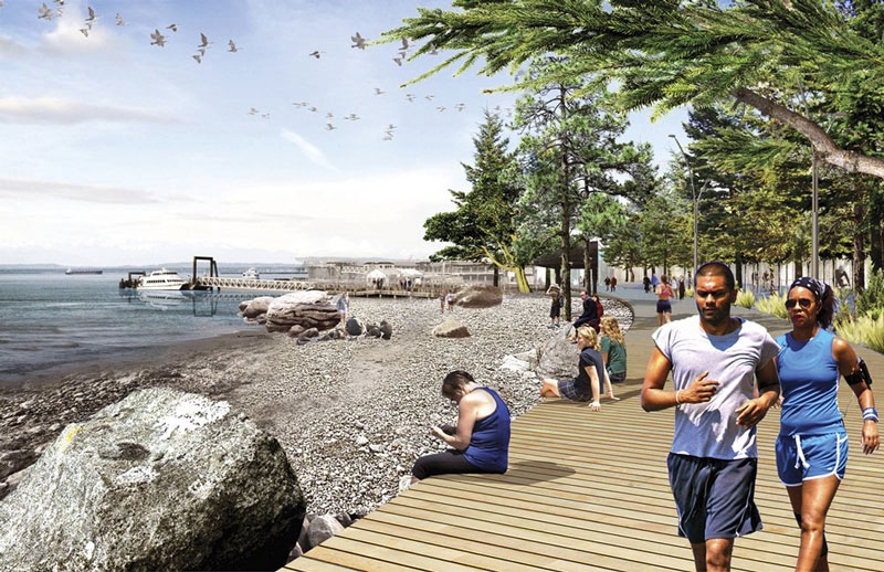
COURTESY OF JAMES CORNER FIELD OPERATIONS AND CITY OF SEATTLE
An architectural rendering shows what a Pioneer Square beach at the foot of Washington Street could look like.
ONCE IN A WHILE, strolling along Seattle’s waterfront, you can catch glints of sunlight on Elliott Bay and smell the briny air.
But for most of the length of Alaskan Way, the waterfront is a wind tunnel of roaring traffic noise and partial, peek-a-boo bay views. Only the seagulls cawing for French fries at Ivar’s hint at the watery, marine world beyond the kitschy tourist shops and aging, creosote-soaked piers.
With the earthquake-vulnerable viaduct scheduled to be removed in 2016, city leaders are planning to redevelop the 26 blocks along the downtown waterfront to transform what’s now parking lots and the backs of buildings into a pedestrian promenade of parks, plazas, lush landscaping and glorious sights of the Olympic Mountains jutting above Puget Sound.
The design is so ambitious, the architects’ drawings so idealized and the bottom line still so uncertain that one headline last spring characterized it all as “Waterfront Wishing.”
But after more than four years of public meetings, design workshops, sticky notes on architects’ renderings, briefings, PowerPoints and pie charts, leaders now believe they’ve come up with a way to pay for the park and keep it active and safe. Before it ever gets built, though, they have to define and refine hundreds of details and — perhaps the biggest challenge of all — convince everyone that they can realize such an ambitious vision.
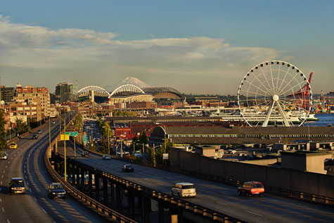
BENJAMIN BENSCHNEIDER / THE SEATTLE TIMES
The planned removal of the viaduct will reconnect Seattle’s waterfront, as seen recently from Victor Steinbrueck Park, with the Pike Place Market and other downtown neighborhoods. The timeline for the project is uncertain.

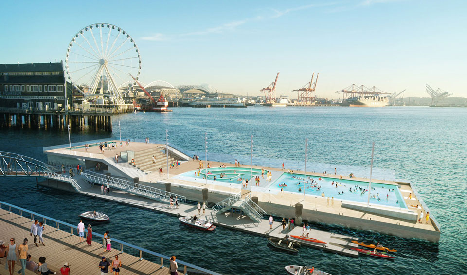
COURTESY OF JAMES CORNER FIELD OPERATIONS AND CITY OF SEATTLE
From a viewpoint looking north, the design features a plaza with a scrim of reflective water and a mist machine near the Great Wheel and another pier for recreation such as a swimming pool barge and small boat rentals.
Hover over the red dots to see what is proposed


Mark Nowlin and Gina Cole / The Seattle Times
And a grand vision it is.
Where a padlocked gate now keeps homeless people off a collapsing, Washington Street boat landing, plans envision a sandy beach with restored tidelands to nurture juvenile salmon.
Where Union Street ends abruptly at First Avenue in a stub and a drop off, a new public viewing deck will extend out, two stories above Western Avenue, and a large glass elevator will carry visitors to the street below.
The park just south of the Aquarium, today all concrete niches and bolted, steel mesh tables, will be transformed into an expansive plaza with fountains, a scrim of reflective water, intermittent mist and rocks reminiscent of sea stacks along the coast.
Where a warren of narrow stairs now connects the Pike Place Market to Western Avenue and then again to the Aquarium, a wide view walkway will gently traverse the west-facing hillside to an amphitheater of terraced seating.
Just to the north, the rotting former concert piers, now off-limits to crowds, would host an array of active features that could include a swimming pool barge, seasonal skating rink, small boat rentals and the return of sunset concerts.
The pedestrian promenade would be paved in places with wooden planks, to echo the decks of the historic piers. Along other stretches, beach rocks and shells in aggregate would be ground smooth to reveal the muted blues, greens and grays of an overcast day. The entire length would be buffered from a rebuilt Alaskan Way by extensive native plantings and a two-way bike trail.
The price tag is as big as the vision: an estimated $420 million for the waterfront park, with about half projected to come from a yet-to-be-defined local improvement district. And city voters, who just agreed to bump up their property taxes to provide more parks funding, may also be asked to fund a levy to cover part of the construction costs.
Even assuming that the design and funding plans don’t run into public pushback or get watered down by city process, the timeline is still a big question mark. The viaduct can’t be imploded until the Highway 99 tunnel to replace it is completed. But Seattle’s own Big Dig is at a standstill, its star boring machine, Bertha, choked on glacial till.
Meanwhile, the planning and design continues behind the scenes. The city hired rock-star landscape architect James Corner, designer of the celebrated High Line in New York City, to create the overarching scheme. And former Mayor Greg Nickels, who started the planning effort back in 2009, foresaw the need for strong, steady leadership even as elected officials would inevitably come and go.
He appointed a 45-member Central Waterfront Committee that includes business and labor as well as nonprofit leaders. It elected another former mayor, Charles Royer, and civic leader Maggie Walker to co-chair the advisory group.
Walker isn’t a household name, but she helped guide the creation of two successful new urban spaces in the past few years, the Olympic Sculpture Park and South Lake Union Park. She and her husband, who founded WRQ software, are also prominent Seattle philanthropists, but Walker says she’s most proud of her volunteer work where she’s known for leading arts and civic organizations, including the Museum of History & Industry and the Seattle Art Museum, over time and through ambitious projects.
Royer was Seattle’s only three-term mayor, and remains as popular in semiretirement as when he led the city from 1978 to 1990. He brings to the waterfront planning effort political savvy, the ability to foresee pitfalls over the long arc of a city megaproject.
“The biggest challenge is delay,” Royer says. “It gives people time to think up new ideas or different ideas. It’s easy to lose sight of the transformative impact this will have on the city.” But he acknowledges that’s not the only obstacle. He and Walker say they have to convince people that Seattle can successfully manage a downtown park.
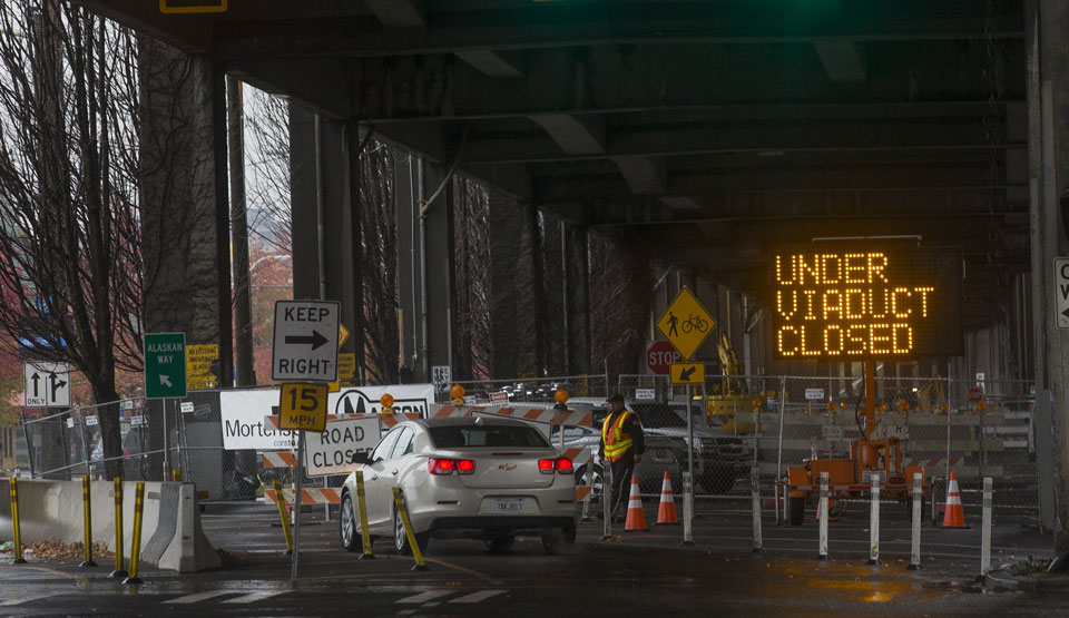
ELLEN M. BANNER / The Seattle TIMES FILE, 2013
Underneath the Alaskan Way Viaduct, a temporary roadway between Madison and Pike streets was being built to accommodate traffic while a new waterfront seawall is built. Noise from the viaduct today drowns out the natural world. Elliott Bay is just a half-block away.
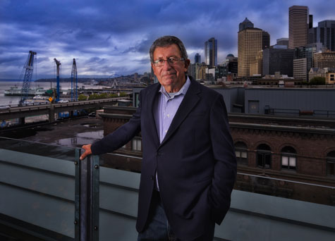
BENJAMIN BENSCHNEIDER / THE SEATTLE TIMES
Former Seattle Mayor Charles Royer, co-chair of the Central Waterfront Committee, will lose his condo building’s rooftop view when an old garage behind him is leveled for a new 10-story residential building. Still, he says the new waterfront will be “transformative” for the city.
ROYER ISN’T joking when he says that living for the past nine years in Pioneer Square has been like living in France in the 17th century.
Dogs run loose, prostitutes loiter in the alleys, people relieve themselves in the gutters. Around are all manner of human misery from drug addiction and alcohol abuse to untreated mental illness and sometimes a menacing combination of all three.
Royer isn’t surprised that when he’s asked about the new waterfront park the first two questions are, “How are you going to take care of it?” and “How are you going to make it safe?”
Walker concurs. “People are dubious. When we say we want to build this beautiful new space, they say, ‘How are you going to make it not like other downtown parks?’ ”
Over the past several years, they and other Central Waterfront Committee members have visited successful urban parks around the country. The High Line and Bryant parks in New York City. The Embarcadero in San Francisco. The Rose Kennedy Greenway in Boston.
What those parks have in common, they say, is that all are run by an organization, in many cases a nonprofit, focused solely on the management and fundraising of the individual park.
BENJAMIN BENSCHNEIDER / THE SEATTLE TIMES
Central Waterfront Committee co-chair Maggie Walker helped guide creation of the Seattle Art Museum’s popular Olympic Sculpture Park.
Several new initiatives around Seattle’s downtown parks could help. A new police chief has stepped up the enforcement of low-level crimes. Foot patrols and bicycle officers have already increased at Occidental Park in Pioneer Square and Westlake Park in the retail center.
The August approval of a new Parks District will provide a much-needed boost in funding for maintenance and operations once the waterfront park is built. Tentative projections call for $3.5 million a year from the parks’ increased budget to keep the new waterfront shining and safe.
But even with all of that, committee members say they’ve become convinced that the waterfront needs its own nonprofit organization focused on raising private donations and scheduling daily and seasonal events to attract people even through the wet, gloomy months of the year.
“The city can’t do it by itself,” says Bob Donegan, president of Ivar’s, whose flagship Acres of Clams restaurant anchors one of the central waterfront’s historic piers. Donegan, who serves on both the stewardship and design subcommittees of the Central Waterfront Committee, says creating a nonprofit stewardship organization addresses both the financing and the operations challenges.
“One of the things we found with the best operations of parks and public spaces around the world is they are managed by a nonprofit foundation. They can raise money and manage a revenue stream so they can always have enough security, landscaping, maintenance and programming to ensure there are people in the park,” Donegan says.
Two years ago, civic leaders created Friends of Waterfront Seattle, and while it’s little more than an executive director and a storefront now, it could become the prime fundraiser and events manager for the future waterfront park.
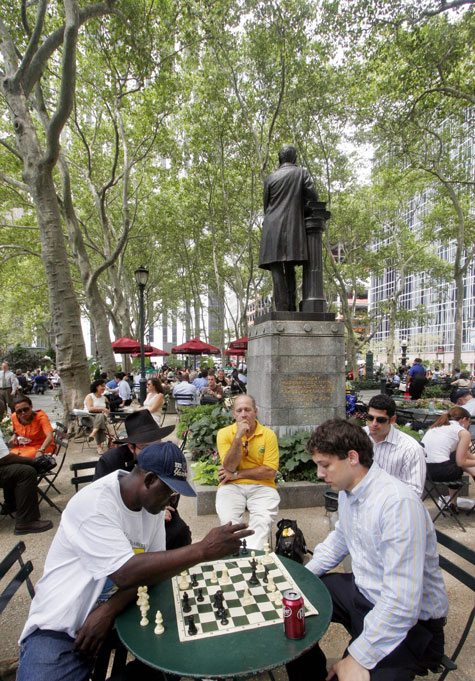
The Associated Press, 2006
Chess players in New York’s rejuvenated Bryant Park, considered a model of park activation and dedicated management.
The Friends organization is inspired most directly by the successful turnaround of Bryant Park in midtown Manhattan. Known in the late 1970s as Needle Park for the unsavory drug scene, the park today enjoys 8 million visitors a year, a $12 million budget financed largely by corporate sponsorships, lush flower beds, outdoor cafes and thousands of brightly colored folding chairs.
The daily calendar is packed with mostly free events from winter ice skating and an ugly Christmas sweater contest to foreign-language lessons, a portable library, bluegrass music and public restrooms as elegant as a Four Seasons hotel’s.
A business improvement district assesses nearby property owners to help pay for maintenance and upkeep. In turn, the park has fired up redevelopment of the surrounding neighborhood.
New York City helped finance a physical renovation three decades ago, but today the city contributes zero — yes, that’s zero — to Bryant Park’s budget.
The co-founder of the Bryant Park Restoration Corporation, Dan Biederman, has parlayed his experience in park revitalization into a private consulting business that has led park makeovers in other cities including Boston, Portland and Dallas.
Now he’s bringing to Occidental and Westlake parks his ideas for packed daily calendars of free events and obsessive attention to details like cleanliness and the number of women in the park, a measure, Biederman says, of a park’s perceived safety.
Friends of Waterfront Seattle is contributing to the funding of both efforts here in hopes of showing on a small scale what could be possible the length of the Seattle Waterfront.
“This is really a proof of concept,” says Leslie Smith, executive director of the Alliance for Pioneer Square, a neighborhood advocacy and development group. “Can we manage our public spaces so that everyone knows they’re clean and safe and full of vibrant activities?”
COURTESY OF JAMES CORNER FIELD OPERATIONS AND CITY OF SEATTLE
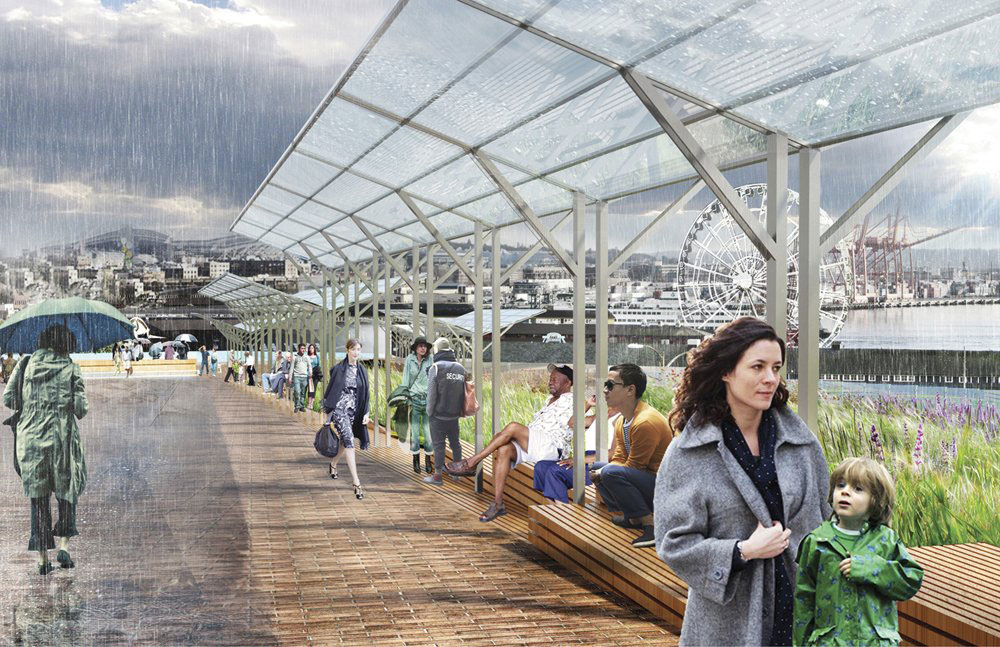
Unlike most of the renderings for the proposed waterfront project, this one of the Overlook Walk Canopy (looking south) shows gray skies and rain.

COURTESY OF JAMES CORNER FIELD OPERATIONS AND CITY OF SEATTLE
An architectural drawing shows the proposed Pier 63 grandstand, looking west across Elliott Bay.
WHILE MANY people who’ve attended the events seeking public feedback on the waterfront park say the plans are exciting, critics are also speaking up. Seattle writer and historian Knute Berger counts himself among the skeptics, not only because of the city’s failure to maintain its current downtown parks but also because of its less than stellar record of running Seattle Center.
Created for the 1962 World’s Fair, the 74-acre arts-and-entertainment center has struggled to maintain the right mix of tenants and events to consistently draw visitors and pay for the upkeep. The Space Needle and the Chihuly Glass Museum are both privately managed and charge entrance fees, raising questions about public access to city-owned space.
“We have a huge civic space that we have trouble maintaining and paying for,” Berger says, “so we’re adding another huge public space?”
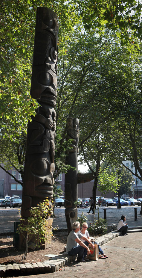
ELLEN M. BANNER / The Seattle Times FILE, 2012
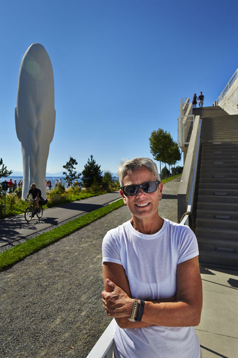
Two totem poles — Sun and Raven, left, and Killer Whale, both carved by Duane Pasco in 1975 — are among the few adornments in Occidental Park in Seattle’s Pioneer Square.
He’s also critical of the Corner design — images that show a Seattle waterfront in perpetual sunshine, teeming with untroubled visitors, and some of the more fanciful ideas, like a mist machine, which made Berger wonder if the designers knew anything about the place.
Berger thinks the design is too slick, the vision not grand but grandiose.
“Everybody thinks opening up the waterfront is a great idea. Everybody understands that the viaduct coming down is a great opportunity. I don’t think the city has sold the plan yet.”
Seattle does have an example of a wildly successful public space: the Pike Place Market. A public preservation and development authority operates it. The Market trains its own security staff and works cooperatively with city police. It has the mix of vibrancy and authenticity that many hope can be re-created on the waterfront.
Market Executive Director Ben Franz-Knight is optimistic that the proposed Friends of Waterfront Seattle can provide the management and operational oversight to make the 26-block park successful. But he and other planners say the nonprofit won’t control every aspect of the new park. The plans will evolve as more people — downtown families with children, business owners, Native American tribes, the Aquarium and Market — get involved and imagine ways to use it.
Corner came up with a very bold vision with the idea that parts of it would be turned over to Seattle to execute, Franz-Knight says. And ultimately, “We have to build it. We have to pay for it. It has to be our space.”
The leaders who have spent the most time with Corner are also the ones most convinced that the Seattle waterfront won’t look like a Southern California shopping mall.
Architect David Miller, who chairs the University of Washington Department of Architecture and wrote a book on environmentally thoughtful Northwest design, notes that Corner grew up in Manchester, England, a working port much like Seattle.
“He has a strong connection to a working waterfront that’s authentic and active, that has that gritty, industrial feel,” Miller says.
Miller and his staff at The Miller Hull Partnership collaborated with Corner on the Market waterfront entrance and the walkway to the Aquarium, which evolved from something monumental to a plan more in keeping with the Market’s historic character and scale.
Corner’s revised walkway now has slides for kids and porch swings for grandparents. There’s a lawn so families can grab food at the Market and picnic while watching the sun set from a hillside above the bay.
COURTESY OF JAMES CORNER FIELD OPERATIONS AND CITY OF SEATTLE
Piers 62 and 63 will be redeveloped for active recreation, including, potentially, a seasonal pool barge.
Share your vision
We know how creative you readers are. Do you have an idea for the waterfront? Some can't-miss attraction or groundbreaking art experience? Can you draw it up and share it with us? It doesn't have to be of the whole waterfront; it could just be a particular feature you think would work well for one pier.
We'll pull out a few of the best submissions to display them in all their glory. Enter here by October 31.
That’s the real vision. Reconnecting Seattle to its shoreline and the natural marine world at our western edge. If they build it, advocates say, we and the world will come, for the amazing views as they open up before us, after sporting events in Pioneer Square, at the ends of rebuilt piers.
But Bertha’s delay could also give rise to doubts and second-guessing. Will a City Council, newly elected by districts instead of citywide in 2015, support a huge new investment in a downtown project? Will the high-concept design win converts in Loyal Heights and the Rainier Valley? Will city voters support spending even more property-tax money to build this grand new park? Will they push leaders to spend it instead on basics like better roads?
Yet, if we blow this chance, will we get another anytime soon? Do we want piecemeal development of our greatest asset or the cohesion of an overarching design? Will we spend another few decades envying the strollers along Vancouver B.C.’s picturesque English Bay or Portland’s lively Riverwalk?
Maybe it’s time to reach for the waterfront we’ve always wished we had.
Lynn Thompson is a Seattle Times staff writer.